AI Answer Evaluation Platform Live Now. Try Free Answer Evaluation Now

Cropmarks
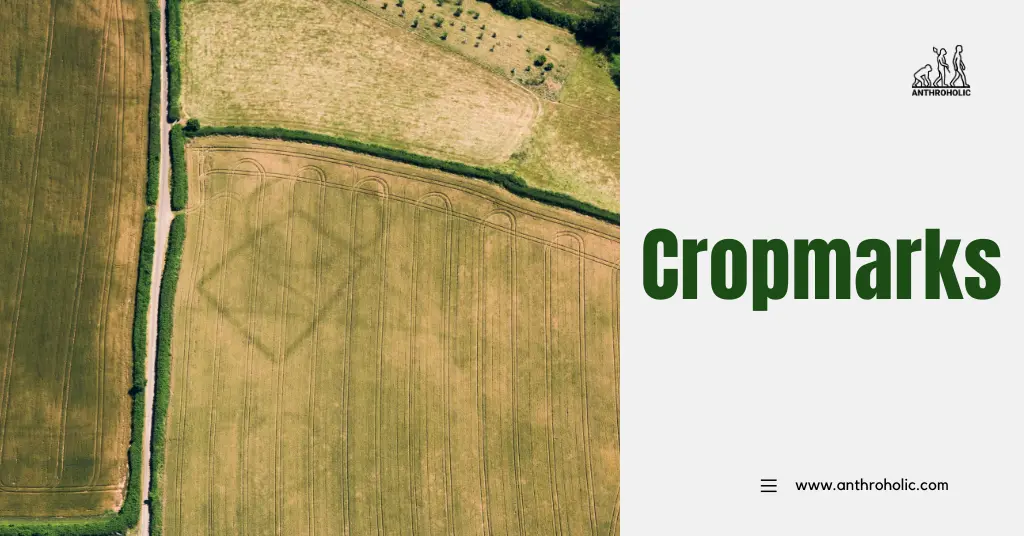
Cropmarks represent a fascinating archaeological phenomenon, providing invaluable information about past human activity and landscapes long vanished. Through aerial photography and satellite imagery, these elusive traces of our ancestors help stitch together pieces of the human story.
Definition of Cropmarks
Cropmarks are patterns visible in growing crops that signify archaeological remains beneath the surface. As their name implies, they can be perceived as variations in crop color, height, and growth rate, corresponding to the hidden subsurface features. They occur due to the interaction between archaeological remains and the growth characteristics of the crops above [1].
Understanding the Formation of Cropmarks
Soil Composition and Moisture
Cropmarks develop due to variations in soil composition and moisture retention. Areas with archaeological remains usually have a different soil composition, with more or less organic matter, affecting moisture levels [2]. This in turn affects plant growth:
- Positive Cropmarks: Over ditches or pits filled with nutrient-rich soil, crops often grow taller and greener.
- Negative Cropmarks: Over stone or brick walls, where the soil is shallow, crops may appear shorter and less vigorous.
Seasonal Influence
Cropmarks are most visible during the growing season, particularly in periods of drought. When water is scarce, the crops’ growth over archaeological features contrasts more starkly with the surrounding crops, making the patterns more apparent [3].
The Role of Aerial Archaeology
The development of aerial archaeology has been instrumental in discovering and interpreting cropmarks. Aerial photographs and more recently, satellite imagery, have allowed archaeologists to uncover a broad range of sites otherwise invisible from the ground [4].
Types of Sites Uncovered
Different types of archaeological sites can be revealed by cropmarks, including:
- Ancient settlements
- Burial mounds
- Roman forts
- Iron Age hillforts
- Prehistoric trackways
- Agricultural field systems
Case Studies
Two case studies illustrate the importance of cropmarks in archaeology.
Stonehenge, England
Aerial surveys around Stonehenge in 2018 led to the discovery of numerous cropmarks, including those of Neolithic houses. This provided evidence that Stonehenge was part of a larger ceremonial landscape and a busy, inhabited place [5].
The Arras Culture, England
Cropmarks in Yorkshire revealed four large square barrows, characteristic of the Arras Culture of the Middle Iron Age. This helped to redefine understanding of the culture’s burial practices and territorial organization.
| Case Study | Features Revealed | Significance |
|---|---|---|
| Stonehenge | Neolithic houses | Evidence of larger ceremonial landscape |
| The Arras Culture | Large square burial barrows | Insights into burial practices, territorial organization |
The Impact of Climate Change on Cropmarks
Climate change can have both positive and negative effects on the visibility of cropmarks. Increased periods of drought may enhance the formation and visibility of cropmarks, revealing previously unknown sites. Conversely, changes in agricultural practices due to climate change may lead to the destruction of archaeological remains.
Challenges and Advances in the Study of Cropmarks
Understanding cropmarks requires careful analysis and interpretation. Some of the challenges include:
- Identifying Cropmarks: It’s not always easy to spot cropmarks, particularly when they are faint or when their patterns are complex.
- Interpreting Cropmarks: Distinguishing between natural and human-made patterns can be challenging.
- Seasonal Variability: Cropmarks may not be visible every year, appearing only in specific environmental conditions.
- Destruction of Cropmarks: Ploughing and modern construction can destroy archaeological remains, eliminating future cropmarks.
Despite these challenges, technological advances are making the study of cropmarks easier and more effective. For instance, digital imaging and satellite technologies have enabled more precise identification and analysis of cropmarks. LIDAR (Light Detection and Ranging) and GIS (Geographical Information Systems) are also transforming how cropmarks are studied.
Cropmarks in Different Cultures
Cropmarks are not limited to any particular region or culture. They appear worldwide, revealing a broad range of archaeological sites. For instance:
- In the Middle East, cropmarks have unveiled ancient irrigation systems and settlement patterns.
- In North America, cropmarks have revealed the locations of Native American earthwork structures.
- In Australia, cropmarks have indicated the locations of prehistoric habitation sites.
This global distribution of cropmarks has expanded our understanding of various cultures and their historical landscapes.
Significance of Cropmarks in Modern Archaeology
Cropmarks have become an indispensable tool in modern archaeology. They have greatly contributed to archaeological surveying, providing cost-effective and non-intrusive means of identifying archaeological sites. More significantly, cropmarks are often the only way to detect certain types of archaeological sites, such as prehistoric farms or Roman camps.
Moreover, cropmarks have a pivotal role in heritage management. By identifying and mapping archaeological sites, they contribute to the protection of cultural heritage, guiding land-use planning and development.
Conclusion
The study of cropmarks offers a unique lens into our past, illuminating the histories that lie beneath our feet. By continuing to refine our methods and technologies, we can further unravel these ephemeral traces of human history and deepen our understanding of our cultural heritage.
References
[1] Bewley, R. (2003). Aerial Archaeology: Developing Future Practice. Amsterdam, Netherlands: IOS Press.
[2] Wilson, D.R. (2000). Air Photo Interpretation for Archaeologists. Stroud, UK: Tempus.
[3] Agache, R. (1982). Discovering the Past from the Air. London, UK: Thames and Hudson.
[4] Campana, S. (2018). Drones in Archaeology. Oxford, UK: Archaeopress Publishing Ltd.
[5] Parker Pearson, M. (2012). Stonehenge: Exploring the Greatest Stone Age Mystery. London, UK: Simon & Schuster.

Related Posts